Commission approves new measures to strengthen WMO’s core priorites
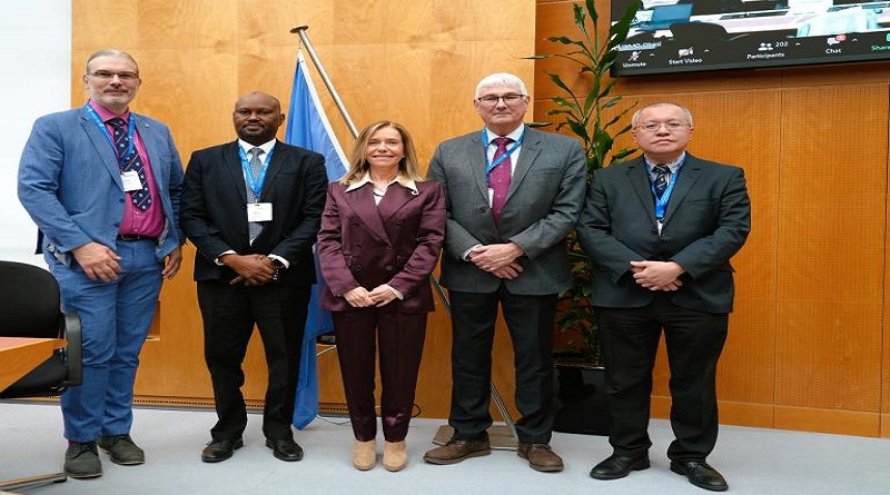
Photo caption: WMO Secretary-General Celeste Saulo with INFCOM President Michel Jean (Canada) and Co-Vice-Presidents Jan Danhelka (Czech Republic), Pascal Waniha (United Republic of Tanzania) and Chan Pak-wai (Hong Kong, China). Photo credit-WMO
The World Meteorological Organisation (WMO) has agreed a sweeping array of measures to improve and expand Earth observations, forecasts and data exchange in the face of rapid technological and societal changes.
Illuminated network connections and data points across a digital map of the earth, highlighting global communication and technology infrastructure.
The measures approved by the Commission for Observations, Infrastructure, and Information Systems (INFCOM) are aimed at strengthening WMO’s backbone and aligning with core priorities including the Early Warnings for All initiative, and the Global Greenhouse Gas Watch, and building the basic observing networks for weather and climate.
The resolutions span the entire the global weather, climate, hydrological and ocean observing infrastructure; modelling and prediction; and information and data exchange. Although highly technical in nature, they are essential to WMO’s mission to supporting climate change adaptation and mitigation, building resilience to extreme weather and fostering sustainable and equitable development.
The decisions reinforce WMO’s commitment to accurate and reliable weather forecasts and life-saving early warnings, whilst also addressing challenges related to climate change, phenomena such as space weather and competition for scarce radio frequencies. They also put WMO on a sound footing to leverage new technologies, including Artificial Intelligence (AI), to enhance Earth system observations and predictions.
“Our world is at a juncture. Ever newer technology will have a profound impact on the way we do business. This shift will allow us to tackle new and emerging products and areas,” said INFCOM President Michel Jean. He said the needs of the user community would continue to be the “lighthouse” for the commission’s work.
Mr Jean (Canada) was re-elected President of the Commission. The newly elected WMO Co-Vice-Presidents are Jan Danhelka (Czech Republic), Pascal Waniha (United Republic of Tanzania) and Chan Pak-wai (Hong Kong, China).
Global Greenhouse Gas Watch
INFCOM approved a draft implementation plan for Global Greenhouse Gas Watch developed by joint Study Group. This will now be forwarded to the WMO Executive Council for approval.
The Global Greenhouse Gas Watch fills critical information gaps and provides an integrated, operational framework that brings together all observing systems, as well as modelling and data assimilation capabilities in relation to greenhouse gas monitoring, striving to reduce the uncertainty in assessing the efficacy of climate action.
It aims to provide a comprehensive monitoring framework and address the urgent need for information that helps to understand and assess the impact of mitigation actions taken by the Parties to the United Nations Framework Convention on Climate Change (UNFCCC) and the Paris Agreement. It takes into consideration both human and natural influences on the levels of greenhouse gases in the atmosphere.
Initial focus will be on the three most important greenhouse gases influenced by human activities, namely carbon dioxide, methane, and nitrous oxide.
The Paris Agreement sets specific targets for maximum rise in global mean temperature and indicates that the means to achieve this target is through the net reduction of GHG emissions.
The resolution recommended for any greenhouse gas monitoring to be carried out with “full transparency,” in accordance with WMO’s fundamental policy for free and unrestricted international exchange of Earth system data.
The resolution envisages a joint advisory group, co-chaired by INFCOM and the WMO Research Board, to guide the implementation of the plan, with the appropriate involvement of external stakeholders.
INFCOM strengthened and updated key provisions of the WMO Integrated Global Observing System (WIGOS) and the associated World Weather Watch.
It decided on the core and recommended sets of satellite data detailed in the Manual on WIGOS covering the satellite data needs for global Numerical Weather Prediction (NWP) application as a first step. It will be followed by the work addressing the satellite data needs of other WMO application areas in an Earth System approach.
INFCOM adopted a new four-year plan for WMO Activities related to Space Weather (2024-2027). This seeks to stengthen the ability of WMO Members to support economic sectors that are prone to threats from Solar eruptions and consequent Space Weather phenomena.
Space weather phenomena, triggered by events occurring on the Sun and in interplanetary space, can affect the Earth’s natural environment and impact satellite communications, global navigation satellite systems, the electrical power grid, and spacecraft operation.
To successfully mitigate these detrimental impacts, extensive observational capabilities on Earth and in space (from the Sun to the Earth) should be accompanied by numerical modelling capabilities representing both the phenomena and their technological impacts.
Drawing on the analogy with operational weather services, WMO has been making efforts to integrate Space Weather within its activities for over a decade. INFCOM adopted the inclusion of a Space Weather Observing system as part of several Amendments to the Manual on the WMO Integrated Global Observing System (WIGOS).
Vibrant illustration of a tech-enhanced landscape with people interacting with large digital screens, data analysis, diverse landscapes, jets, and a symbolic lightbulb floating above.
MS Copilot
WMO Integrated Processing and Prediction System (WIPPS) is a worldwide network of operational centres and provides defined analysis and prediction products which are available among WMO Members and relevant operational organizations.
INFCOM agreed to evolve WIPPS to meet user requirements, support the Early Warnings for All initiative, and follow up on the WMO Unified Data Policy.
The major upgrades are:
To increase the number of analysis and forecast products and to provide these at higher resolution. This update includes some impact-based indexes and the new set of tropical low/cyclone vortex variables that will be beneficial for Members to provide better quality forecasts and warnings. This agreement will significantly increase the amount of core data from Numerical Weather Prediction (NWP), benefitting a wide range of users.
The introduction of five new WIPPS activities (global climate reanalysis and the relevant coordination, vegetation fire and smoke pollution forecasts (VFSP), marine emergency response and global storm surge prediction) to serve more user communities to support their services.
WIS 2.0:
INFCOM decided to significantly advance the new WMO global data sharing system which will become operational at the beginning of next year and which underpins the accuracy of weather forecasts and early warnings and supports climate monitoring and research.
The WMO Information System, known as WIS 2.0, ushers in a future where predicting and preparing for weather-related events, tracking changes in the environment, and contributing to climate research will be more efficient and effective than ever before.
INFCOM provided guidance, software and training to Members on how to transition from the current data exchange systems to the next generation of data sharing facilities. To further facilitate this transition, open-source software and training is being offered to the WMO Centres located in all Member countries.
Currently, over 50 countries are exchanging data in real-time, with the majority using the WIS2 in a box software and participating in training sessions organized by WMO.
Early Warnings for All
Many countries lack satisfactory monitoring and real-time data of evolving threats and some do not have proper access to satellite products or to tools such as vertical profiles of the atmosphere, high resolution modelling (atmospheric, oceanic, hydrologic), ensembles or nowcasting products. Many do not have proper IT infrastructure needed to support data collection and coding/de-coding.
Thus, INFCOM endorsed a plan to tackle these capacity gaps. Some of the main efforts will be:
Improving the ground monitoring of evolving threats by implementing the Global Basic Observation Network (GBON) and the associated Systematic Observation Financing Facility (SOFF). This is a program designed to address the challenges of the least developed countries by a financing scheme and by technical support and oversight;
Developing additional ground monitoring networks through the WMO regional associations;
Improving accessibility and usability of the global and regional Numerical Prediction products through the WMO Integrated Processing and Prediction System (WIPPS), which makes defined prediction products and services operationally available to the WMO community. The aim is to increase the number of regional centres and the range of products available and accessible to members;
Supporting Members to ensure access to satellite data and products, including real time data and nowcasting products, including new modalities for the members to access the wide and extending range of satellite products.


